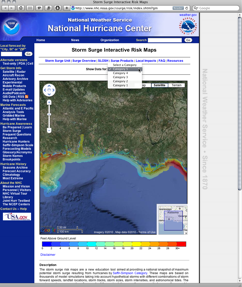
 They’re not precise enough to use for planning purposes, but the National Hurricane Center has created a neat tool to show projections for where hurricanes are likely to drive storm surge. Using it is as easy as visiting their Storm Surge Interactive Risk Maps webpage, selecting a category of storm (1-5) you’d like to see mapped, then zooming into the area you’re curious about.
Again, this isn’t intended for fine-scale decision making, but looks handy for outreach. Right now it covers the Gulf of Mexico coast and the Atlantic from Florida to Maine for categories 1-4, with category 5 projections extending as far north as North Carolina.