Straight from the National Hurricane Center press-release: ![]()
Product Changes for the 2010 Hurricane Season’s
Effective May 15, the National Hurricane Center will implement important changes in some of its text and graphical products. It will also make some additions to its Web site and experimental products. This is part of a continuing effort at the National Hurricane Center to expand and enhance its level of service.
Changes:
- Watches and warnings for tropical storms and hurricanes along threatened
coastal areas will be issued 12 hours earlier than in previous years. Tropical
storm watches will be issued when tropical storm conditions are possible along
the coast within 48 hours. Tropical storm warnings will be issued when those
conditions are expected within 36 hours. Similar increases in lead-time will
apply to hurricane watches and warnings.- The format of the Tropical Cyclone Public Advisory is changing. The most significant changes are:
- The Public Advisory will be organized into sections. Within these sections, keywords will be used to assist the human eye and computer software to find specific information more readily.
- The summary section of the advisory will move to the top of the product, immediately following the headline. The summary section will contain more information than it did previously.
- Watch and warning information will be organized differently and be presented in list or bullet form.
- A summary section, identical to the one found in the Public Advisory, will be added to the Tropical Cyclone Update whenever storm information (e.g., position, intensity, movement, pressure, etc.) changes from the previous Advisory.
- The genesis forecasts for the risk of tropical cyclone development will be provided to nearest 10 percent, in both the text and graphical Tropical Weather Outlooks. In previous years, only risk categories (low/medium/high) were given.
- The National Weather Service and its National Hurricane Center will begin using the generic term “post-tropical” to refer to any system that no longer possesses sufficient tropical characteristics to be considered a tropical cyclone. Post-tropical cyclones can continue to carry heavy rains and strong winds. Some post-tropical cyclones will go on to become fully extratropical, that is, derive their energy from the temperature contrast between warm and cold air masses. Another type of post-tropical cyclone is the “remnant low”, a weak system with limited thunderstorm activity and winds of less than tropical storm strength.
- The Saffir-Simpson Hurricane Wind Scale will become operational. The scale keeps the same wind speed ranges as the original Saffir-Simpson Scale for each of the five hurricane categories, but no longer ties specific storm surge and flooding effects to each category.
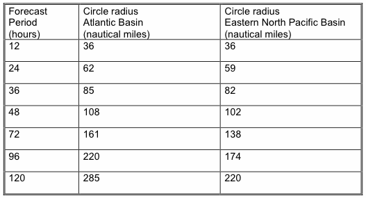
- The size of the tropical cyclone forecast cone will be adjusted. The cone represents the probable track of the center of a tropical cyclone, and is formed by enclosing the area swept out by a set of imaginary circles placed along the forecast track (at 12, 24, 36 hours, etc.). The size of each circle is set so that two-thirds of historical official forecast errors over a 5-year sample fall within the circle. The circle radii defining the cones in 2010 for the Atlantic and eastern North Pacific basins are given in the table below.
Forecast Period (hours)Experimental Products
(Note that the timeliness and accuracy of these products cannot be guaranteed)
- Podcast RSS/XML feed for time when the media pool is activated:
http://www.nhc.noaa.gov/audio/index.shtml
(The media pool is typically activated when a hurricane watch is issued for any portion of the U.S. contiguous coastline.)- Live video/audio feed of top-of-the-hour hurricane briefings when the media pool is activated: http://www.emergency.info/nhc/
- Various GIS products:
http://www.nhc.noaa.gov/gis/- Experimental Tropical Cyclone Storm Surge Exceedance Products:
http://www.nhc.noaa.gov/pns2_2010.shtmlOn the Web
National Hurricane Center Product Description Document-A User’s Guide to Hurricane Products: http://www.nhc.noaa.gov/pdf/NHC_Product_Description_20100217.pdf
Post Tropical Cyclone Wording:
http://www.nhc.noaa.gov/pns1_2010.shtmlWatch and Warning Criteria Change:
http://www.nhc.noaa.gov/watchwarn_changes.shtmlTropical Cyclone Public Advisory Format Change:
http://www.nhc.noaa.gov/help/tcp.shtmlTropical Cyclone Update Change:
http://www.nhc.noaa.gov/tcu_example.shtmlGraphical Tropical Weather Outlook:
http://www.nhc.noaa.gov/aboutnhcgraphics.shtml#GTWOSaffir Simpson Hurricane Wind Scale:
http://www.nhc.noaa.gov/aboutsshs.shtmlDefinition of NHC Track Forecast Cone:
http://www.nhc.noaa.gov/aboutcone.shtml